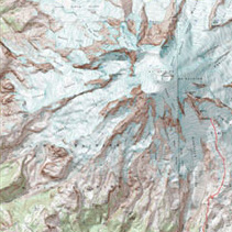
Topographic Maps
MyTopo maintains a database of the most up-to-date topographic maps available for the US and Canada. Maps can be ordered by the traditional US quad sheet or customer centered.
Custom-Center your Map Anyplace in the US or Canada with MyTopo
Topographic maps, satellite imagery, aerial photos, hunting unit maps, hiking maps, and lake maps can be easily ordered; then MyTopo prints and ships them within 24 hours for quick delivery.
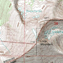
MyTopo maintains a database of the most up-to-date topographic maps available for the US and Canada. Maps can be ordered by the traditional US quad sheet or customer centered.
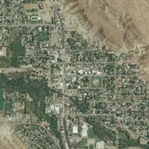
Every 2-3 years the US Department of Agriculture takes photographs of approximately ⅓ of the United States. MyTopo offers the opportunity to customize these photos to zoom in on one property or zoom out to cover a larger area.
MyTopo provides beautiful satellite imagery for the US and Canada.
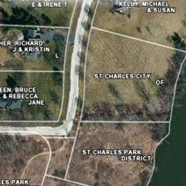
MyTopo allows customers to overlay private land boundaries, with owner’s name or parcel number. This data layer can be added to topographic maps, aerial photos or satellite imagery.
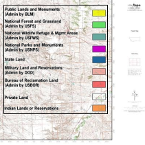
Overlay public land boundaries on custom topographic, aerial or satellite maps. Know whether you are on Bureau of Land Management property, US Forest Service Land, within a National Park, on a Reservation, state land or private property. MyTopo offers the ability to overlay public land boundaries on all of its base map types.
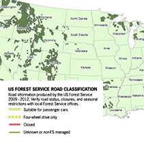
Gaining access to public land can be tricky. MyTopo offers the ability to overlay the USFS network of roads and trails on all of its maps to help its customers determine how to access and travel through public land areas.
MyTopo provides a unique map that is a blend of an aerial base map with a topo map overlaid to show recent changes to the landscape combined with the contours and symbology valued in topographic maps.

MyTopo hunt area maps provide the Western US public land hunter with 1:100,000 Bureau of Land Management (BLM) base maps with Game Management Unit (GMU) boundaries as an overlay and each unit centered on its own pre-made map. The Eastern states public land maps combine our custom topographic maps and aerial photos with boundaries for popular public lands, wildlife management areas, State lands, forests and parks.
We’ve teamed up with Backpacker Magazine to create custom, pre-planned adventures you can purchase on waterproof maps for in-field navigation. Use with your GPS or your smartphone for a complete mapping experience.
Maps can cover portions of multiple USGS quads to reduce the number of maps needed in the field and focus the map on the area of interest.
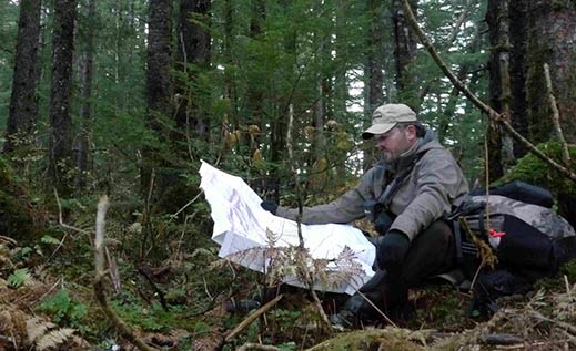
Maps are printed on waterproof, tear-resistant paper for reliable use in the field under the harshest weather conditions. They are made to last through many seasons of use. Option to order with laminated finish for use with dry-erase markers.
MyTopo maps are printed with UV-fade resistant inks.
Folded for use in the field, or rolled for framing, MyTopo customers can select whichever option is best for their map
MyTopo allows customers to select map zoom levels from 1:1,000 up to 1:50,000 to zero in on less than a one mile square area or zoom out to cover a 20-30 mile radius.
MyTopo offers quick and easy order for stock maps, including every USGS 7.5 minute map, Game Management Unit Maps for 8 western states, and over 3500 maps of public hunting areas such as wildlife management areas.
MyTopo maps come in three popular ready-made frame sizes, 18 x 24 inches, 24 x 36 inches, and 36 x 48 inches.
MyTopo offers two banner size maps, 4 x 5 foot and 5 x 8 foot, for large wall coverings.
MyTopo prints and ships all map orders of 20 or less maps within 24 hours.
MyTopo has over twenty years of experience providing custom-printed maps for use in the field, home and office. Maps are printed and shipped within 24 hours for quick delivery.
The most popular options are: United State Geological Survey (USGS) 7.5 topographic maps ordered by quad or custom center your map any place in the US; aerial photographs, satellite imagery, or public land hunting maps, including Game Management Unit Maps for the western US or Wildlife Management Areas for the eastern US. Canadian topographic maps and satellite imagery also available.
MyTopo can overlay private land boundaries to provide landowner names and parcel boundaries on its topos or satellite maps. In addition to private land data, customers can add public land boundaries, US Forest Service Roads and Trails, and GMU boundaries.
The custom maps and GMU maps are printed on waterproof paper for use in the field. Maps can also be laminated for use with a dry erase marker or grease pen.
To learn more or place an order, visit www.mytopo.com.
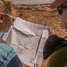
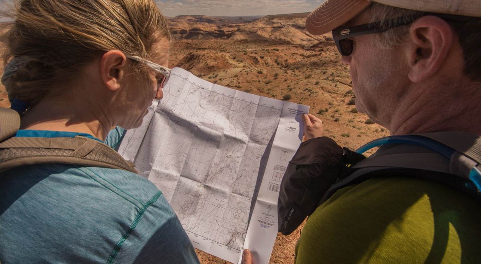
“We just received our 3′ by 4′ custom topo map. I just wanted to report that we are very satisfied with the quality of the map. The detail is terrific and we appreciate that it is on high quality paper. We can’t wait to get it mounted and displayed in our log house in the woods. Your web site is terrific and I really appreciated that we could preview the map before making the purchase. I was also surprised and delighted by how quickly it was printed and put in the mail.” Photo credit: Michael Lanza, The Big Outside
Dan and Wanda A.
24 hours for quick map delivery!
MyTopo provides 7.5 minute, 1:24,000 USGS quad maps (the new US Topo and the Classic Quad). Quickly order by the quad or opt to customize. GMU maps for 8 western states are available to order. The GMU maps are listed by tag number within each state. All maps will print/ship within 24 hours for quick delivery to your mailbox.